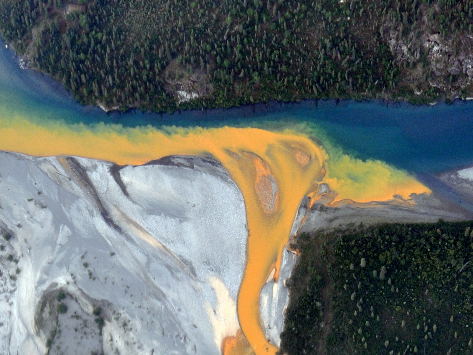
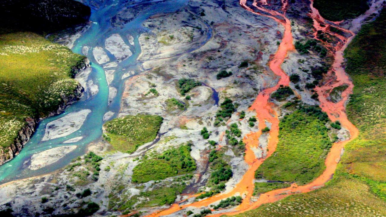
Dozens of Alaska’s most remote streams and rivers are turning from a crystal clear blue into a cloudy orange, and the staining could be the result of minerals exposed by thawing permafrost, new research in the Nature journal Communications: Earth and Environment finds.
For the first time, a team of researchers from the National Park Service, U.S. Geological Survey, the University of California, Davis, and other institutions have documented and sampled some of the impaired waters, pinpointing 75 locations across a Texas-sized area of northern Alaska’s Brooks Range.
These degraded rivers and streams could have significant implications for drinking water and fisheries in Arctic watersheds as the climate changes, the researchers said.
“The more we flew around, we started noticing more and more orange rivers and streams,” said lead author Jon O’Donnell, an ecologist for the NPS’ Arctic Inventory and Monitoring Network. “There are certain sites that look almost like a milky orange juice.
Those orange streams can be problematic both in terms of being toxic but might also prevent migration of fish to spawning areas.”

Visible from space
O’Donnell first noticed an issue when he visited a river in 2018 that appeared rusty despite having been clear the year prior. He began asking around and compiling locations while grabbing water samples when possible in the remote region, where helicopters are generally the only way to access the rivers and streams.
“The stained rivers are so big we can see them from space,” said Brett Poulin, an assistant professor of environmental toxicology at UC Davis who was a principal investigator in the research. “These have to be stained a lot to pick them up from space.”
Poulin, whose expertise is in water chemistry, thought the staining looked similar to what happens with acid mine drainage, except no mines are near any of the impaired rivers, including along the famed Salmon River and other federally protected waters.
One hypothesis is that the permafrost, which is essentially frozen ground, stores minerals and as the climate warmed, the metal ores that were once locked up were exposed to water and oxygen, resulting in the release of acid and metals.
“Chemistry tells us minerals are weathering,” Poulin said. “Understanding what’s in the water is a fingerprint as to what occurred.”
The impacted rivers are on federal lands managed by Bureau of Land Management, Fish and Wildlife Service and NPS, including Gates of the Arctic and Kobuk Valley national parks.
Poulin and Ph.D. candidate Taylor Evinger analyzed initial samples, then collected their own on a trip last August, while others took samples in June and July. This year, they will take three trips during the summer to collect additional samples.
Acidic water releasing metals
Some samples from the impaired waters have a pH of 2.3 compared to the average pH of 8 for these rivers. This means the sulfide minerals are weathering, resulting in highly acidic and corrosive conditions that release additional metals. Elevated or high levels of iron, zinc, nickel, copper and cadmium have been measured.
“We see a lot of different types of metals in these waters,” Evinger said. “One of the most dominant metals is iron. That’s what is causing the color change.”
While O’Donnell first noticed a change in 2018, satellite images have turned up stained waters dating back to 2008.
“The issue is slowly propagating from small headwaters into bigger rivers over time,” he said. “When emergent issues or threats come about, we need to be able to understand them.”
Understanding risk
The researchers are in the second year of a three-year grant aimed at understanding what is happening in the water, modeling what other areas may be at risk and assessing implications for drinking water and fishing stocks.
The problem is growing and affecting habitat, water quality and other ecological systems, turning healthy areas into degraded habitats with fewer fish and invertebrates. If rural communities rely on these rivers for drinking water, they could require treatment eventually, and the fishing stocks that feed local residents could be affected.
“There’s a lot of implications,” O’Donnell said. “As the climate continues to warm, we would expect permafrost to continue to thaw and so wherever there are these types of minerals, there’s potential for streams to be turning orange and becoming degraded in terms of water quality.”
More work is needed to better understand the problem and whether rivers and streams can rebound, perhaps after cold weather promotes permafrost recovery.
“I think there will be a lot more detailed work to follow up to address some of the uncertainties that we currently have,” O’Donnell said.
Scientists from Alaska Pacific University, Colorado State University, University of Alaska Anchorage and UC Riverside also contributed to the research.
The research was funded by U.S. Geological Survey–NPS Water Quality Partnership program, the U.S. Geological Survey Changing Arctic Ecosystem Initiative and the NPS Arctic Inventory and Monitoring Program.
Media Resources
Media Contacts:
- Brett A. Poulin, UC Davis Department of Environmental Toxicology, bapoulin@ucdavis.edu
- Jon O’Donnell, National Park Service, jaodonnell@nps.gov
- Emily C. Dooley, College of Agricultural and Environmental Sciences, 530-650-6807, ecdooley@ucdavis.edu
- Kat Kerlin, UC Davis News and Media Relations, 530-750-9195, kekerlin@ucdavis.edu
USGS Alaska Science Center research page
Media kit: Photos, captions and b-roll
